The Permian Basin in West Texas and the Appalachian Basin stretching from New York to Kentucky are the two heavyweights of American unconventional oil and gas. Together they account for over a third of U.S. crude oil production and the majority of domestic shale gas output. But despite their outsized importance, geologists have rarely put them next to each other and asked: how do these two provinces actually compare?
That's exactly what April Patel and her colleagues at the U.S. Energy Information Administration set out to do. In their study, "Cross-comparison of stacked unconventional plays of Delaware and Appalachian basins: reservoir characteristics and production profiles," Patel and co-authors Olga Popova, Emily Geary, Gary Long, Jeffrey Little, Steven Grape, and Elizabeth Panarelli bring together the EIA's extensive well-level datasets to examine how stacked plays in two geologically very different settings compare — and what those differences mean for how we develop them.
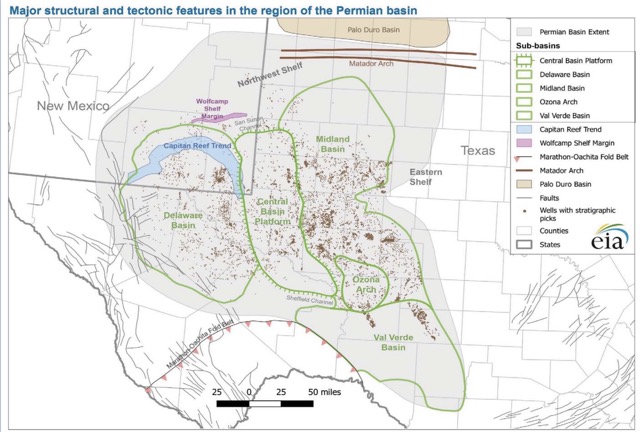
The Delaware Basin — the western half of the larger Permian Basin — is a geologist's layer cake. Rapid subsidence during Pennsylvanian and Wolfcampian time created an exceptionally thick sedimentary fill, and the result is one of the most vertically stacked unconventional provinces on the planet. Up to nine or ten discrete shale intervals sit within a single vertical section reaching roughly 10,000 feet. The Wolfcamp formation alone — divided into its A, B, C, and D benches — averages about 1,800 feet thick, with porosity ranging from 2% to 12% and permeabilities low enough to require multistage hydraulic fracturing. Above it, the Bone Spring formation adds several more prospective intervals.
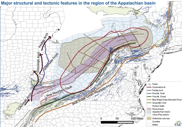
The Appalachian Basin tells a different story. It's an elongate foreland basin stretching over a thousand miles, and its principal shale targets — the Marcellus (Middle Devonian, roughly 390 million years old) and the deeper Utica–Point Pleasant (Upper Ordovician, about 445 million years old) — were deposited under anoxic marine conditions in a foreland trough paralleling the developing Appalachian Mountains. Fewer stacked intervals here, typically two or three primary targets versus the Delaware's nine or ten, but each one is laterally enormous. The Marcellus spans five states and varies in thickness from zero to 950 feet.
In practical terms, April Patel and her team show that these geological differences translate into fundamentally different development strategies. In the Delaware Basin, operators can target multiple pay zones from a single well pad — drilling into the Wolfcamp A on one lateral, the Bone Spring on another, and coming back later for deeper benches. As of mid-2021, horizontal wells made up over 84% of producing wells in the Delaware Basin, with average lateral lengths around 8,700 feet and growing. Multi-well pads with nine or more wells have become common. It's a vertical-inventory game.
The Appalachian Basin runs on a different engine. Rather than stacking targets vertically, operators here have focused on lateral scaling — progressively longer horizontal segments, faster drilling, and optimized completions, mostly within one or two reservoir horizons. In West Virginia, average lateral lengths grew from roughly 2,500 feet in 2007 to over 7,000 feet by 2016, with some Utica wells reaching 19,000 feet. Overall Appalachian natural gas production surged from 7.8 billion cubic feet per day in 2012 to nearly 24 billion cubic feet per day by 2017 — driven almost entirely by efficiency gains rather than by tapping additional formations.
"It's two end-member models of unconventional development," is how the comparison reads. One province grows by drilling down through more layers; the other grows by drilling out farther through fewer.

This kind of cross-basin thinking matters. Patel's work at EIA is part of the agency's broader low-permeability play mapping program, which produces the structure, thickness, and production maps widely used across the oil and gas community — by industry, government agencies, financial institutions, and academia. By placing the Delaware and Appalachian basins in a common analytical framework, the study offers a template for understanding how geological inheritance shapes development strategy, and for evaluating whether techniques refined in one province can transfer to another.
April Patel's path to this work is itself an unusual one. Before joining EIA, she worked as a Research Associate at Pacific Northwest National Laboratory's Joint Global Change Research Institute, where she co-authored studies on global climate modeling — including the widely cited RCP4.5 radiative forcing pathway that helped inform the IPCC's Fifth Assessment Report. She also served as a Peace Corps Volunteer and worked in geospatial data science before moving into upstream oil and gas analysis. It's a career that bridges climate science and petroleum geology, and it brings a distinctive analytical perspective to the EIA team's work on unconventional plays.
The cross-comparison study builds on several earlier publications by Patel and the same team, including presentations at the 2018 AAPG-SPE Eastern Section Joint Meeting in Pittsburgh on Appalachian production growth, the 2019 AAPG Annual Convention in San Antonio on Wolfcamp play characteristics, and EIA reports on the Bone Spring formation and Midland Basin Wolfcamp.
Read the full publication here.